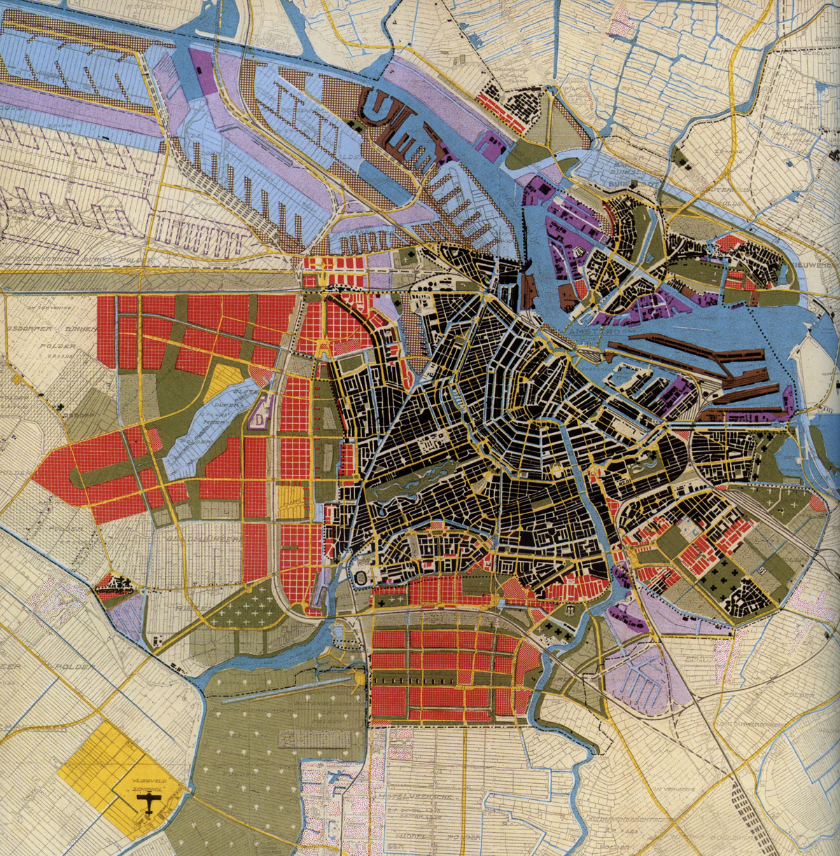
Main Flat Extension Plan of Amsterdam. From Eesteren y From Lohuisen, 1934
PLAN EXTENSION OF AMSTERDAM
General Uitbreidngsplan (UAP)
Cornelis van Eesteren y Theo Van Lohuizen
Amsterdam, Holland. 1934
In 1929, Van Eesteren begin its collaboration with the Department of Public Works of the City of Amsterdam where the responsibility would be granted control over the development of the city. That request would materialize in the Extension Plan 1934 -directing that it would conduct the necessary equipment alongside Van Lohuizen- and is the basic document for orderly urban growth materialization of the main Dutch city during the interwar period and its extension to 1960.
The Plan proposes Van Eesteren contain indiscriminate expansion of the city and reducing land consumption, integrating production and work spaces into new growth areas defined rational and orderly. All, according to the estimated residential demand is derived from the projected population growth. His conception of urban planning urban development embodied in the definition of neighborhood districts or surfaces containing both for housing and land reserves prepared to accommodate parks complementary services, equipment and, even, the space for commercial uses, administrative and work. The minimum cluster unit is set to a certain number of homes and is seen as the basic functional organization interrelates around the school that is reasonably feasible and necessary. A group of minimum units results in the district in which other services and facilities as may be provided collectively, structured around a neighborhood center.
To define this functional support tights road formed by ordered, in districts that integrate organized by superblocks in which residential units could insert these minimum. Complexes room separate pieces are conceived formally as rhythmic and repeated volumetric elements to form a balancing game between residence and complementary services on the basis that structures the whole road.
El General Uitbreidngsplan (UAP) Van Eesteren projecting urbanistically reflects the concerns and ideas of so-called aesthetic neoplastic or D'Stijl movement that would arise in the Netherlands in the first third of the twentieth century. The Neo would base their approaches on the definition of free volumetric intertwined and free and asymmetrical composition of its elements. On the other hand, social ideals, of equality and service to the working class represented by this Plan would be contained in the proclamations that the International Congresses of Modern Architecture (CIAM) would authenticate a more extensive. The call Athens Charter be adopted simultaneously in those years and clearly reflected the ideological conception. Keep in mind that Van Eesteren be president of CIAM from 1930 to 1947 and, thus, the influence of his thinking is clear.
The plan would take several decades to materialize on the ground and their ideas and proposals would implement in a large group of neighborhoods on the outskirts of Amsterdam, located to the west and south of the city Dutch. Districts as Slotermeer, Osdorp, Slotervaart y Buitenveldertbaan, inter alia.
THE UAP is the basic reference for much of contemporary urbanism that would develop later in Europe. Their influence is seen in which ideas and budgets there are present and intertwined implemented largely urban legislation which then developed in many countries. The pattern of European urban expansion experienced during the second half of the twentieth century stems from Van Eesteren proposals and colleagues would imagine in the early decades of the century.
References:
Planning in Amsterdam. Da Van Berlage a Eesteren. PWPoint Paolo Pucci
The Amsterdam Extension Plan of 1934. Doctoral Thesis Julian Galindo Gonzalez
Cornelis van Eesteren. Hide de Wikipedia
Amsterdam and the five water projects. Julian Galindo Conference, Vimeo

Aerial view of the new expansion proposed by the Plan based on what has been done on the basis of South Amsterdam Plan HP. Berlage de 1905

Made districts 1963 south and west of the city from the proposed UAP. Image of Van Eesteren book on Julian Galindo

Sloterplas The big lake in the center of all the districts drawn west of Amsterdam